Tennessee Point Labyrinth
(scroll to bottom for photo gallery)
Location: Marin Headlands: Tennessee Point on Tennessee Point Trail fromCoastal Trail above Rodeo Beach/Fort Cronkhite, Mill Valley, California 94941
Starting Point: Trailhead at Fort Cronkhite/Rodeo Beach parking lot, Mitchell Road
For driving directions, input “Fort Cronkhite parking lot” into your GPS map system.
Info links:
For all web links, if a link doesn’t jump directly, copy and paste into browser.
Marin Headlands Map link (National Park Service):
https://www.nps.gov/goga/planyourvisit/upload/map_mahe_150429_508_2021.pdf
Fort Cronkhite Information and Map link (Golden Gate National Parks Conservancy):
https://www.parksconservancy.org/parks/fort-cronkhite
San Francisco to Fort Cronkhite MUNI bus info link:
https://www.parksconservancy.org/services/marin-headlands-express
Distance:
Tennessee Point and Tennessee Point Labyrinth are about a mile from the Fort Cronkhite parking area at Rodeo Beach, half the distance on the Coastal Trail, and the other half on the Tennessee Point Trail, which may not be clearly marked on trail markers. This is not a long hike but there are some inclines, which adds some cardio exercise.
Considerations: (some of this post overlaps with the Battery Townsley post)
• The Fort Cronkhite parking lot by Rodeo Beach is fairly large, but there is also parking along Mitchell Road with paths to the beach.
• Bathrooms (as well as beach showers) are available at the Fort Cronkhite parking lot by Rodeo Beach.
• There are some pretty steep drop offs along the cliff side stretch above Hawk Tail Beach (which I did not know had the name Hawk Tail Beach until looking up info for these hike notes… that deep split between cliffs always reminds me of school lessons on the Bay of Fundy). Keep an eye on children or others who may not be as attentive to fences and steep drops.
• Bus service from San Francisco to Fort Cronkhite may be affected by health and safety restrictions. See link above for current info.
• For those walking along the periphery of Tennessee Point as well as the unmarked trails closer to the cliff edges, use extreme caution. Not only are the drops steep, but cliffs can be unstable and crumble underfoot at any time.
The trail:
You can’t have a bad start to a hike when the launch point is Rodeo Beach in the Marin Headlands near Fort Cronkhite. I have been to Rodeo Beach countless times, on warm days and cold, sunny and overcast, and the scenery has never been less than stunning.
The Coastal Trail trailhead leading toward Tennessee Point and Tennessee Point Labyrinth starts at the beach end of the parking lot, right at the end of Mitchell Road. See other great hikes also starting from here: Battery Townsley, Hill 88 from Rodeo Beach, and Rodeo Lagoon Loop – Marin Headlands. Another nearby hike described from a different starting point is Old Bunker Road.
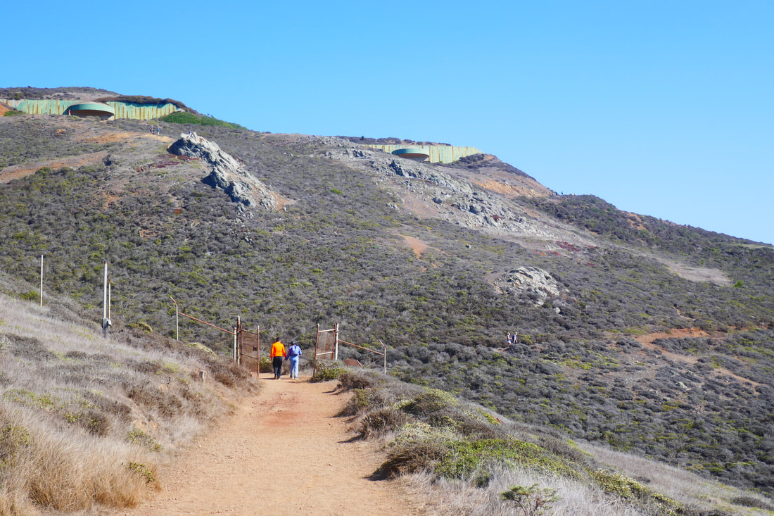
A brief uphill climb leads to a sign marking a sharp left up a path lined with charming wood fencing. The wooden fence leads straight toward the Pacific, and then makes a sharp right to continue uphill facing north, with the sharp drop revealing Hawk Tail Beach on the left on the outbound journey.
The minimal barrier that keeps one from falling down the steep cliff into the deep cove of Hawk Tail Beach is worth making a stop at for the glorious view above the steep, narrow beach. We’ve seen emergency crews during rescue practice here, for good reason.
Continue uphill to where the trails split out, with a Coastal Trail sign indicating the path uphill toward Battery Townsley and points beyond. This is where we split to the left to follow north parallel to the coast, rather than climbing uphill.
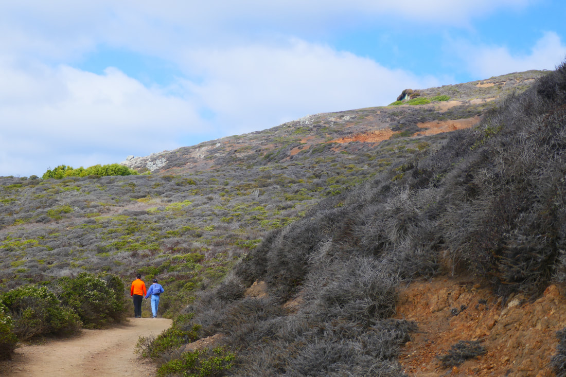
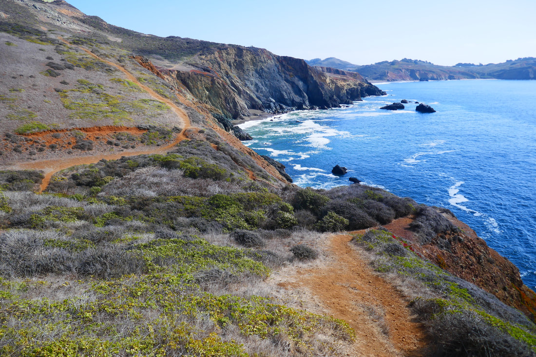
Tennessee Point Trail is easily visible by not necessarily labeled by a sign. Actually, there are what we refer to as the “middle trail” as well as a “lower trail,” both of which lead north toward Tennessee Point and the Labyrinth. (What we call the “upper trail” takes walkers above to Battery Townsley, looming above at the top of the ridge.) For the hike shown in this photo gallery we took the middle trail which meanders through chaparral terrain: lots of coyote brush and no large trees.
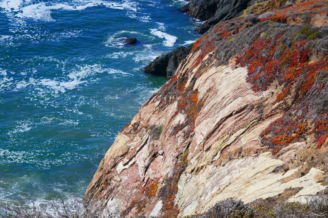
The textures and subtle colors of plants and rusty colored trail dirt are a visual treat whether looking up the hill, or down toward the water’s edge, a dramatic view no matter what stretch of this trail you’re on.
Look westward over the Pacific, and on a really clear day, you may get an amazing view of the Farallon Islands.
One of my favorite parts of hiking this part of the Marin Headlands is more about sound than sight. There is a buoy bell that can be heard in the distance, which invariably makes me think of the opening scene in “Jaws” when the young girl is swimming in the moonlight by the buoy. (This stretch of coast has its share of great white sharks!)
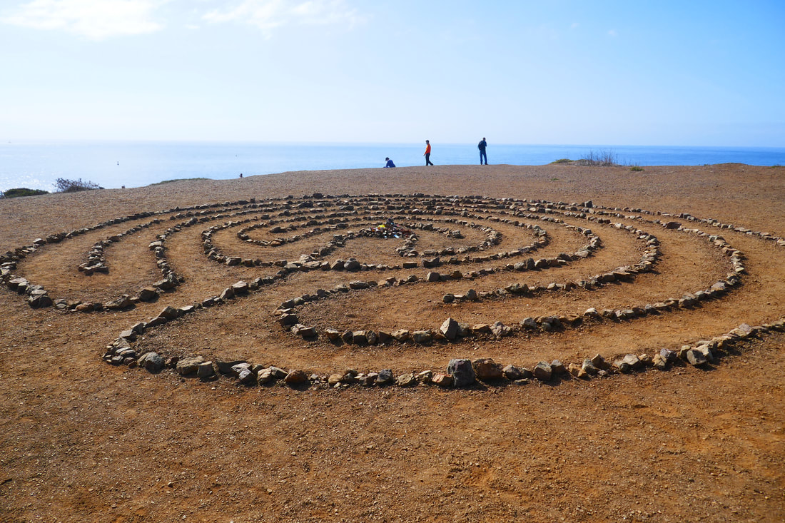
Continue along until the trail views out toward the ocean and leads through an old metal fence. The Labyrinth cliff area is visible rising to the left. Make your way through the tree tunnel section of the path and turn left to walk onto Tennessee Point.
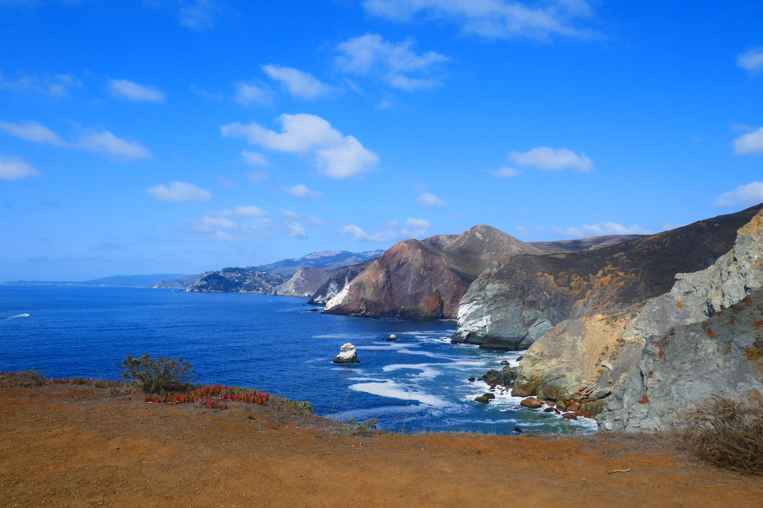
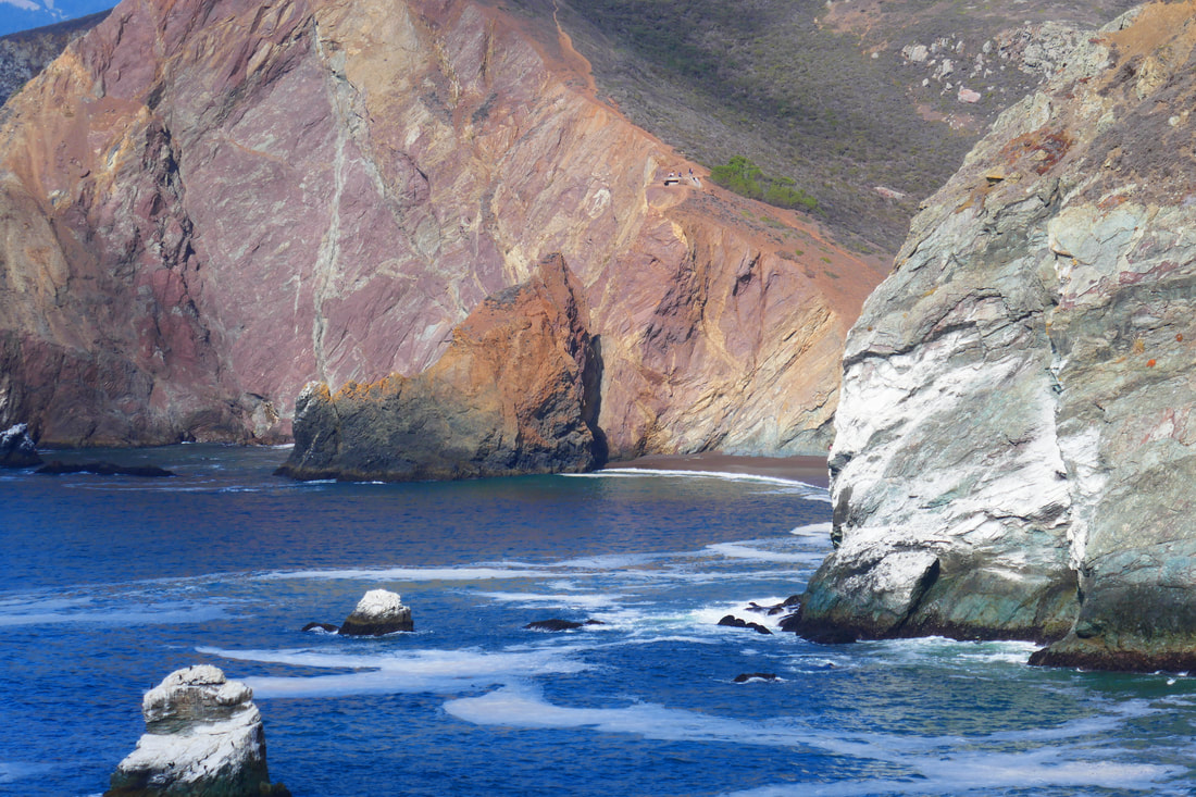
After all the hikes I’ve done along the California coast, you’d think I wouldn’t be totally stunned by any view on the coast, but the view north from here really knocked me out. Large white patches on red and green cross sections of dramatic geological formations, repeating in jutting patterns northward, were really something to see against a bright blue sky. The view from the Labyrinth area is truly breathtaking.
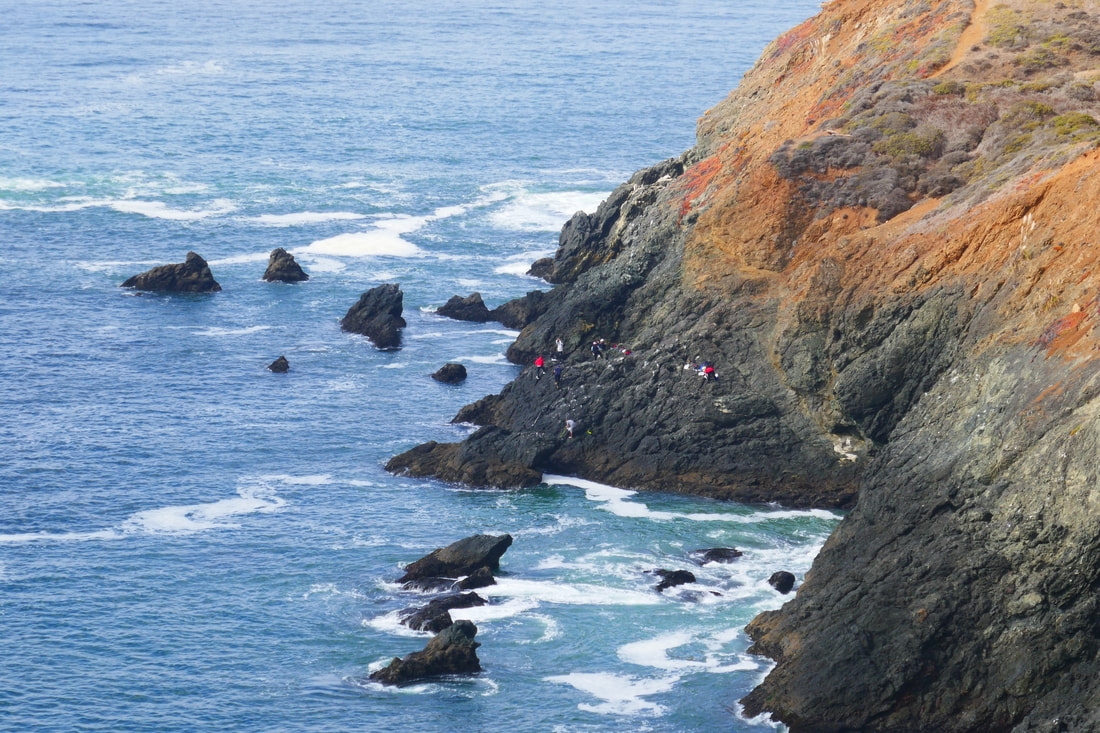
We took a lower trail for part of the way back, which required more caution with our footing for some steep parts, and avoiding the trail edges that are truly along the cliff edge. A view far below to rocky outcroppings revealed small colorful dots which turned out to be people who had made their way down for the view or for fishing.
The view heading back south is equally beautiful, with Rodeo Beach, Rodeo Lagoon and Bird Island in the midrange view, and a San Francisco silhouette beyond that. The last stretch back down toward Rodeo Beach and the parking area is always dramatic with the rocky outcropping above Hawk Tail beach giving a different vibe on the way back, and the charming wooden fences leading to a view of surfers below on the last uphill part of this hike always being a visual treat.
(Tennessee Point Labyrinth Hike Notes were originally paired with the “Teamwork” Insights post.)
Click Insights/Hike Update News for inspiring reflections. Browse hikes on the main Hikes page or on the Hike Search by Area page. Check out selected articles and interviews under Media. Click World Walks to see or share favorite family-friendly walks! Stay in touch with Lisa Louis and HikingAutism via Contact. See products with inspiring designs that support the efforts of HikingAutism under Support/Shop. The Links page lists a loose collection of helpful information links.
Check the Home page for the broader background story. If you’re not able to take one of these Northern California hikes, hopefully you can enjoy the photo galleries at the bottom of each hike page! Feel free to share and follow on Facebook at HikingAutism, follow on Twitter at @HikingAutism and Instagram at lisalouis777
(scroll to bottom for photo gallery)
Location: Marin Headlands: Tennessee Point on Tennessee Point Trail fromCoastal Trail above Rodeo Beach/Fort Cronkhite, Mill Valley, California 94941
Starting Point: Trailhead at Fort Cronkhite/Rodeo Beach parking lot, Mitchell Road
For driving directions, input “Fort Cronkhite parking lot” into your GPS map system.
Info links:
For all web links, if a link doesn’t jump directly, copy and paste into browser.
Marin Headlands Map link (National Park Service):
https://www.nps.gov/goga/planyourvisit/upload/map_mahe_150429_508_2021.pdf
Fort Cronkhite Information and Map link (Golden Gate National Parks Conservancy):
https://www.parksconservancy.org/parks/fort-cronkhite
San Francisco to Fort Cronkhite MUNI bus info link:
https://www.parksconservancy.org/services/marin-headlands-express
Distance:
Tennessee Point and Tennessee Point Labyrinth are about a mile from the Fort Cronkhite parking area at Rodeo Beach, half the distance on the Coastal Trail, and the other half on the Tennessee Point Trail, which may not be clearly marked on trail markers. This is not a long hike but there are some inclines, which adds some cardio exercise.
Considerations: (some of this post overlaps with the Battery Townsley post)
• The Fort Cronkhite parking lot by Rodeo Beach is fairly large, but there is also parking along Mitchell Road with paths to the beach.
• Bathrooms (as well as beach showers) are available at the Fort Cronkhite parking lot by Rodeo Beach.
• There are some pretty steep drop offs along the cliff side stretch above Hawk Tail Beach (which I did not know had the name Hawk Tail Beach until looking up info for these hike notes… that deep split between cliffs always reminds me of school lessons on the Bay of Fundy). Keep an eye on children or others who may not be as attentive to fences and steep drops.
• Bus service from San Francisco to Fort Cronkhite may be affected by health and safety restrictions. See link above for current info.
• For those walking along the periphery of Tennessee Point as well as the unmarked trails closer to the cliff edges, use extreme caution. Not only are the drops steep, but cliffs can be unstable and crumble underfoot at any time.
The trail:
You can’t have a bad start to a hike when the launch point is Rodeo Beach in the Marin Headlands near Fort Cronkhite. I have been to Rodeo Beach countless times, on warm days and cold, sunny and overcast, and the scenery has never been less than stunning.
The Coastal Trail trailhead leading toward Tennessee Point and Tennessee Point Labyrinth starts at the beach end of the parking lot, right at the end of Mitchell Road. See other great hikes also starting from here: Battery Townsley, Hill 88 from Rodeo Beach, and Rodeo Lagoon Loop – Marin Headlands. Another nearby hike described from a different starting point is Old Bunker Road.
A brief uphill climb leads to a sign marking a sharp left up a path lined with charming wood fencing. The wooden fence leads straight toward the Pacific, and then makes a sharp right to continue uphill facing north, with the sharp drop revealing Hawk Tail Beach on the left on the outbound journey.
The minimal barrier that keeps one from falling down the steep cliff into the deep cove of Hawk Tail Beach is worth making a stop at for the glorious view above the steep, narrow beach. We’ve seen emergency crews during rescue practice here, for good reason.
Continue uphill to where the trails split out, with a Coastal Trail sign indicating the path uphill toward Battery Townsley and points beyond. This is where we split to the left to follow north parallel to the coast, rather than climbing uphill.
Tennessee Point Trail is easily visible by not necessarily labeled by a sign. Actually, there are what we refer to as the “middle trail” as well as a “lower trail,” both of which lead north toward Tennessee Point and the Labyrinth. (What we call the “upper trail” takes walkers above to Battery Townsley, looming above at the top of the ridge.) For the hike shown in this photo gallery we took the middle trail which meanders through chaparral terrain: lots of coyote brush and no large trees.
The textures and subtle colors of plants and rusty colored trail dirt are a visual treat whether looking up the hill, or down toward the water’s edge, a dramatic view no matter what stretch of this trail you’re on.
Look westward over the Pacific, and on a really clear day, you may get an amazing view of the Farallon Islands.
One of my favorite parts of hiking this part of the Marin Headlands is more about sound than sight. There is a buoy bell that can be heard in the distance, which invariably makes me think of the opening scene in “Jaws” when the young girl is swimming in the moonlight by the buoy. (This stretch of coast has its share of great white sharks!)
Continue along until the trail views out toward the ocean and leads through an old metal fence. The Labyrinth cliff area is visible rising to the left. Make your way through the tree tunnel section of the path and turn left to walk onto Tennessee Point.
After all the hikes I’ve done along the California coast, you’d think I wouldn’t be totally stunned by any view on the coast, but the view north from here really knocked me out. Large white patches on red and green cross sections of dramatic geological formations, repeating in jutting patterns northward, were really something to see against a bright blue sky. The view from the Labyrinth area is truly breathtaking.
We took a lower trail for part of the way back, which required more caution with our footing for some steep parts, and avoiding the trail edges that are truly along the cliff edge. A view far below to rocky outcroppings revealed small colorful dots which turned out to be people who had made their way down for the view or for fishing.
The view heading back south is equally beautiful, with Rodeo Beach, Rodeo Lagoon and Bird Island in the midrange view, and a San Francisco silhouette beyond that. The last stretch back down toward Rodeo Beach and the parking area is always dramatic with the rocky outcropping above Hawk Tail beach giving a different vibe on the way back, and the charming wooden fences leading to a view of surfers below on the last uphill part of this hike always being a visual treat.
(Tennessee Point Labyrinth Hike Notes were originally paired with the “Teamwork” Insights post.)
Click Insights/Hike Update News for inspiring reflections. Browse hikes on the main Hikes page or on the Hike Search by Area page. Check out selected articles and interviews under Media. Click World Walks to see or share favorite family-friendly walks! Stay in touch with Lisa Louis and HikingAutism via Contact. See products with inspiring designs that support the efforts of HikingAutism under Support/Shop. The Links page lists a loose collection of helpful information links.
Check the Home page for the broader background story. If you’re not able to take one of these Northern California hikes, hopefully you can enjoy the photo galleries at the bottom of each hike page! Feel free to share and follow on Facebook at HikingAutism, follow on Twitter at @HikingAutism and Instagram at lisalouis777