Bay Tree Trail-Huddart Park
(scroll to bottom for photo gallery)
Location: Huddart Park is noted as being at 1100 Kings Mountain Road, Woodside, CA. From Kings Mountain Road, look for the sign for Huddart Park to turn onto Huddart Park Road, which leads to the entry gate.
Starting Point: The parking lot near the Huddart Park entry gate is close to a trailhead with a sign for a short connector trail leading to the Bay Tree Trail. Huddart Park covers a wide area and has several parking areas. If you wish to park near a toilet facility, nearby Zwierlein Picnic area also has a connector trail to the Bay Tree Trail.
Info links:
For all web links, if a link doesn’t jump directly, copy and paste into browser. (Information links may change. We do our best to update.)
Huddart Park information link (San Mateo County Parks):
https://parks.smcgov.org/huddart-park
Huddart Park Trail map (San Mateo County Parks):
https://parks.smcgov.org/sites/parks.smcgov.org/files/HuddartMap-Nov2018-FINAL-web.pdf
Huddart Park brochure link (San Mateo County Parks):
https://parks.smcgov.org/documents/huddart-park-brochure
Distance:
The Bay Tree Trail itself as noted as an easy trail of 0.7 miles. From the trailhead near the Huddart Park entry parking area, there is a 0.1 mile connector trail to get to the Bay Tree Trail. If you started there and went to the end of the trail and back, it would be a round trip total of 1.6 miles. If parking at the Zwierlein parking area for easy toilet facility access, the connector trail to the Bay Tree Trail is 0.3 miles. Huddart Park is a large complex of many connecting trails, so visitors looking for a longer hike can include the Bay Tree Trail to create a several mile hike.
Considerations:
• Huddart Park is quite large, and has many trails, parking and picnic areas. Though there are many trail markers, it is still advisable to have a copy of their brochure/trail map, preferably downloaded onto your mobile device as all paper copies were gone on our recent visit.
• There is a small per vehicle fee, pay info at main entrance.
• There are toilet facilities at several locations around Huddart Park, usually adjacent to named picnic and parking areas.
• Pay attention to posted notices, including info on mountain lions, ticks, poison oak, and rattlesnakes.
• Dogs are not allowed at Huddart Park.
• Allow time to find your way around the trails, with plenty of time to make your way back to your trailhead. If in doubt, find one of the service roads that leads back to the main entrance.
The trail:
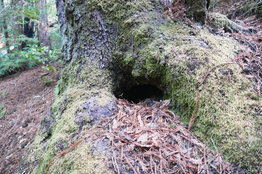
Huddart Park is a large county park set in what was formerly redwood logging territory, logged to fill the voracious need for lumber starting in the Gold Rush Era. Fortunately, new redwood trees have grown where others were felled long ago, and this county park offers many trails over a broad area to enjoy not only coast redwood trees but also live oak, madrone, and Douglas firs.
There are many trails, long and short, to explore in Huddart Park. Bay Tree Trail is noted as one of the easy trails, and from end to end is 0.7 miles. Though that sounds short, there is a variety of scenery along the trail, which makes it feel longer. There are charming wooden fences, inviting wooden footbridges, hairpin trail turns, and a variety of trees that lead hikers along.
We parked at the lot right near the park entrance, because the trailheads for the Bay Tree Trail as well as another trail we wanted to try, the Chickadee Nature Trail, were near the entrance. We added another 0.3 miles out and 0.3 miles back to the Zwierlein picnic and parking area for a toilet stop.
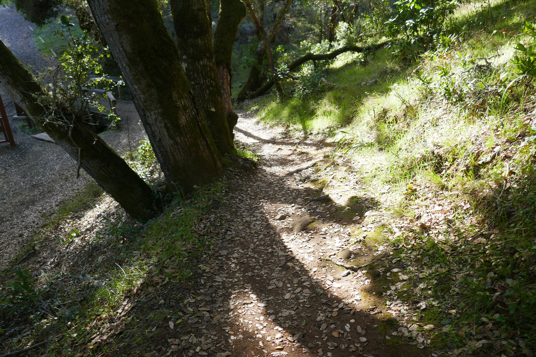
The 0.1-mile connector trail from the entrance parking area trailhead to reach the official Bay Tree Trail trailhead was very charming, featuring wooden fences and dirt trails softened by leaves and pine needles.
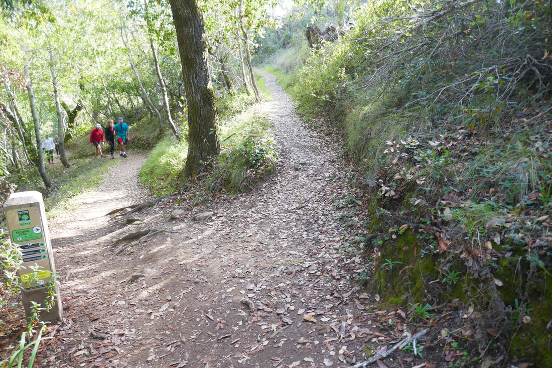
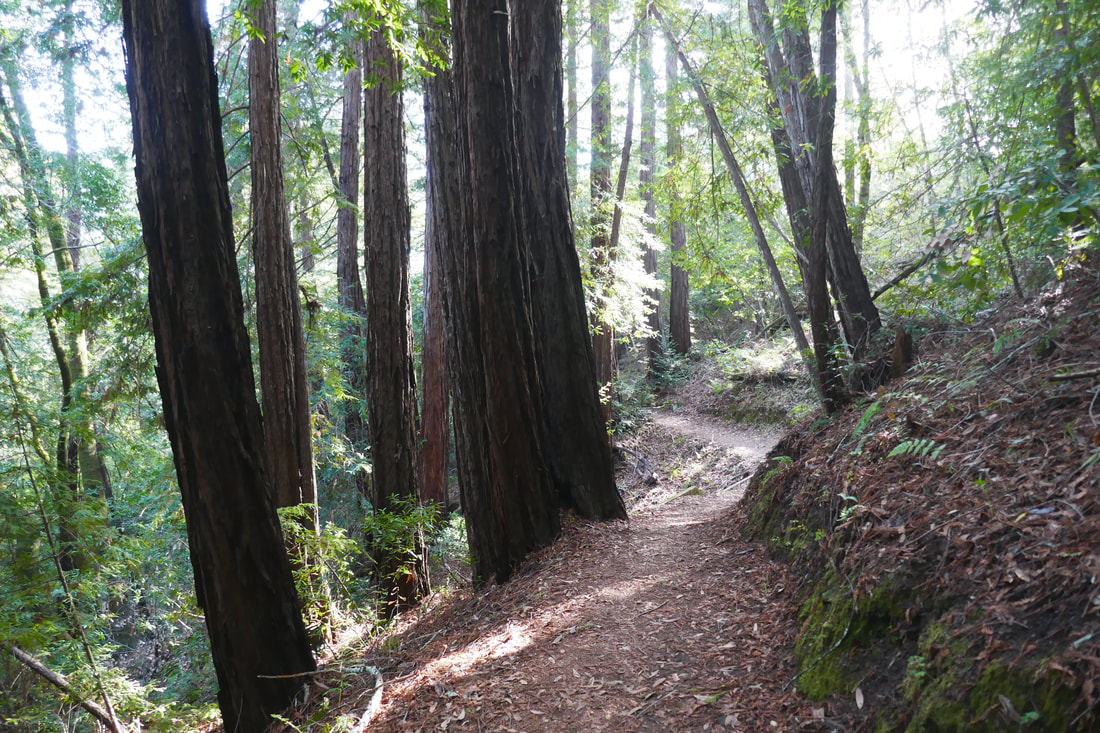
Once on the Bay Tree Trail, the opening stretch was largely lined with redwood trees. After the intersection with the Sequoia Trail, well-marked by one of the many trail markers in Huddart Park, there was a shift to more deciduous trees for a stretch, then we hit another redwoods, moss and ferns section of trail, a pattern which repeated itself.
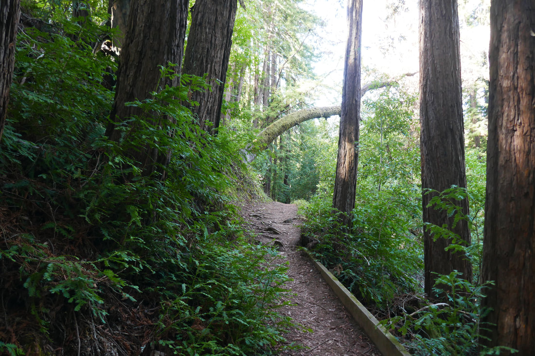
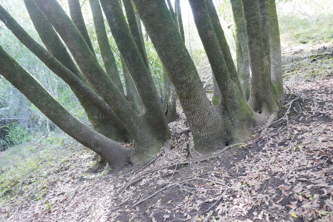
Multiple tree trunks stemming from a single broad base, extending out in graceful curves like a fountain, are a visual hallmark of the Bay Tree Trail.
Despite the sunny weather on our hike, the redwood sections of trail stayed shady and cool. The light broke through more clearly at the later end of the trail. Wooden footbridges, narrow tree tunnels, and broader breaks in the tree cover overhead eventually lead to the West Meadow Picnic Area, an open area beyond the trail intersection of Bay Tree Trail and Richards Road Trail.
This post covers only the Bay Tree Trail. Walkers might take a break here at the West Meadow Picnic Area and return by the same trail. We took a different trail back, but I repeat the importance of having a paper trail map or a downloaded electronic trail map on hand. Despite the many trail markers and signs at Huddart Park, which we were impressed by, there are some areas that are difficult to make a connection between to reach a slightly distant trailhead. We not only used a map but a compass to find one of our trails, because key information was missing on some trail markers. Maps are our friends!
All in all, we found the trails we walked at Huddart Park to be quite enjoyable and plan to go back to explore many more miles of trail.
(Bay Tree Trail-Huddart Park Hike Notes were originally paired with the “The Bright Spot” Insights post.)
Click Insights/Hike Update News for inspiring reflections. Browse hikes on the main Hikes page or on the Hike Search by Area page. Check out selected articles and interviews under Media. Click World Walks to see or share favorite family-friendly walks! Stay in touch with Lisa Louis and HikingAutism via Contact. See products with inspiring designs that support the efforts of HikingAutism under Support/Shop. The Links page lists a loose collection of helpful information links.
Check the Home page for the broader background story. If you’re not able to take one of these Northern California hikes, hopefully you can enjoy the photo galleries at the bottom of each hike page! Feel free to share and follow on Facebook at HikingAutism, follow on Twitter at @HikingAutism and Instagram at lisalouis777
(scroll to bottom for photo gallery)
Location: Huddart Park is noted as being at 1100 Kings Mountain Road, Woodside, CA. From Kings Mountain Road, look for the sign for Huddart Park to turn onto Huddart Park Road, which leads to the entry gate.
Starting Point: The parking lot near the Huddart Park entry gate is close to a trailhead with a sign for a short connector trail leading to the Bay Tree Trail. Huddart Park covers a wide area and has several parking areas. If you wish to park near a toilet facility, nearby Zwierlein Picnic area also has a connector trail to the Bay Tree Trail.
Info links:
For all web links, if a link doesn’t jump directly, copy and paste into browser. (Information links may change. We do our best to update.)
Huddart Park information link (San Mateo County Parks):
https://parks.smcgov.org/huddart-park
Huddart Park Trail map (San Mateo County Parks):
https://parks.smcgov.org/sites/parks.smcgov.org/files/HuddartMap-Nov2018-FINAL-web.pdf
Huddart Park brochure link (San Mateo County Parks):
https://parks.smcgov.org/documents/huddart-park-brochure
Distance:
The Bay Tree Trail itself as noted as an easy trail of 0.7 miles. From the trailhead near the Huddart Park entry parking area, there is a 0.1 mile connector trail to get to the Bay Tree Trail. If you started there and went to the end of the trail and back, it would be a round trip total of 1.6 miles. If parking at the Zwierlein parking area for easy toilet facility access, the connector trail to the Bay Tree Trail is 0.3 miles. Huddart Park is a large complex of many connecting trails, so visitors looking for a longer hike can include the Bay Tree Trail to create a several mile hike.
Considerations:
• Huddart Park is quite large, and has many trails, parking and picnic areas. Though there are many trail markers, it is still advisable to have a copy of their brochure/trail map, preferably downloaded onto your mobile device as all paper copies were gone on our recent visit.
• There is a small per vehicle fee, pay info at main entrance.
• There are toilet facilities at several locations around Huddart Park, usually adjacent to named picnic and parking areas.
• Pay attention to posted notices, including info on mountain lions, ticks, poison oak, and rattlesnakes.
• Dogs are not allowed at Huddart Park.
• Allow time to find your way around the trails, with plenty of time to make your way back to your trailhead. If in doubt, find one of the service roads that leads back to the main entrance.
The trail:
Huddart Park is a large county park set in what was formerly redwood logging territory, logged to fill the voracious need for lumber starting in the Gold Rush Era. Fortunately, new redwood trees have grown where others were felled long ago, and this county park offers many trails over a broad area to enjoy not only coast redwood trees but also live oak, madrone, and Douglas firs.
There are many trails, long and short, to explore in Huddart Park. Bay Tree Trail is noted as one of the easy trails, and from end to end is 0.7 miles. Though that sounds short, there is a variety of scenery along the trail, which makes it feel longer. There are charming wooden fences, inviting wooden footbridges, hairpin trail turns, and a variety of trees that lead hikers along.
We parked at the lot right near the park entrance, because the trailheads for the Bay Tree Trail as well as another trail we wanted to try, the Chickadee Nature Trail, were near the entrance. We added another 0.3 miles out and 0.3 miles back to the Zwierlein picnic and parking area for a toilet stop.
The 0.1-mile connector trail from the entrance parking area trailhead to reach the official Bay Tree Trail trailhead was very charming, featuring wooden fences and dirt trails softened by leaves and pine needles.
Once on the Bay Tree Trail, the opening stretch was largely lined with redwood trees. After the intersection with the Sequoia Trail, well-marked by one of the many trail markers in Huddart Park, there was a shift to more deciduous trees for a stretch, then we hit another redwoods, moss and ferns section of trail, a pattern which repeated itself.
Multiple tree trunks stemming from a single broad base, extending out in graceful curves like a fountain, are a visual hallmark of the Bay Tree Trail.
Despite the sunny weather on our hike, the redwood sections of trail stayed shady and cool. The light broke through more clearly at the later end of the trail. Wooden footbridges, narrow tree tunnels, and broader breaks in the tree cover overhead eventually lead to the West Meadow Picnic Area, an open area beyond the trail intersection of Bay Tree Trail and Richards Road Trail.
This post covers only the Bay Tree Trail. Walkers might take a break here at the West Meadow Picnic Area and return by the same trail. We took a different trail back, but I repeat the importance of having a paper trail map or a downloaded electronic trail map on hand. Despite the many trail markers and signs at Huddart Park, which we were impressed by, there are some areas that are difficult to make a connection between to reach a slightly distant trailhead. We not only used a map but a compass to find one of our trails, because key information was missing on some trail markers. Maps are our friends!
All in all, we found the trails we walked at Huddart Park to be quite enjoyable and plan to go back to explore many more miles of trail.
(Bay Tree Trail-Huddart Park Hike Notes were originally paired with the “The Bright Spot” Insights post.)
Click Insights/Hike Update News for inspiring reflections. Browse hikes on the main Hikes page or on the Hike Search by Area page. Check out selected articles and interviews under Media. Click World Walks to see or share favorite family-friendly walks! Stay in touch with Lisa Louis and HikingAutism via Contact. See products with inspiring designs that support the efforts of HikingAutism under Support/Shop. The Links page lists a loose collection of helpful information links.
Check the Home page for the broader background story. If you’re not able to take one of these Northern California hikes, hopefully you can enjoy the photo galleries at the bottom of each hike page! Feel free to share and follow on Facebook at HikingAutism, follow on Twitter at @HikingAutism and Instagram at lisalouis777