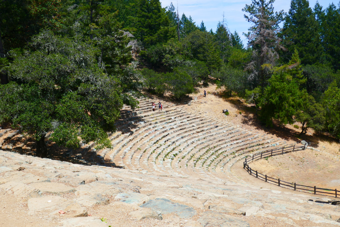
Mountain Theater from Bootjack Campground
(scroll to bottom for photo gallery)
Location: Bootjack Campground parking area, Mount Tamalpais State Park
Starting Point: Bootjack parking area, 895 Panoramic Highway, Mill Valley, CA 94941
Info links:
For all web links, if a link doesn’t jump directly, copy and paste into browser.
For online map application searches, input “Bootjack Campground Parking”
Mount Tamalpais State Park info link (CA State Parks):
https://www.parks.ca.gov/?page_id=471
Muir Woods and Vicinity Trail Map (National Park Service):
https://www.nps.gov/goga/planyourvisit/upload/map-muwo-trail-2019-small.pdf
Mount Tamalpais brochure with map (California State Parks):
https://www.parks.ca.gov/pages/471/files/MountTamalpaisSPFinalWebLayout110816.pdf
Distance:
We ended up taking an unmarked trail so don’t have official distance information. Since the Bootjack Trail, which has a lot of distance added with its many switchbacks, says 0.8 miles to the Mountain Theater, my guess is that our off-trail adventure was more like 0.4 miles for the straight up climb, with 0.3 miles more to get to the Mountain Theater once we reached the top of the hill to the Old Mine Trail and then Old Mine Spur to the Mountain Theater Trail.
Considerations:
• The parking area is fairly large, but as is the case at many trailheads, it gets more crowded on weekends.
• There are toilets at the trailhead parking area.
• Follow health, safety signs, and wildlife information signs.
• Having a poison oak scrub like Technu is handy for any trail.
• As with any Bay Area outing, bring layers. You may be hot in the sun one moment and shivering under fog and a chilly breeze the next.
The trail:
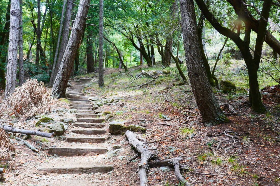
The Bootjack camp sites rise up to the right from behind the bathroom buildings. Stone stairways start hikers out, winding through various campsites, and come to some trail signs, one of which directs hikers along Bootjack Trail. There’s a somewhat faded path stretch that then connects to some wooden steps.
After the stairs, there is a service road with signs. We did not turn right and walk a few yards to see the Bootjack Trail sign. Instead, we went straight ahead on a lesser-marked trail called the Riding and Hiking Trail which would connect us to the Easy Grade Trail as another way up to the Mountain Theater.
We did not, however, take the sharp left along the more clearly worn Riding and Hiking Trail, but instead started chugging straight up the mountain. It still seemed like a marked trail, and at that point, I hadn’t realized that we’d missed the Bootjack Trail connector by a few yards.
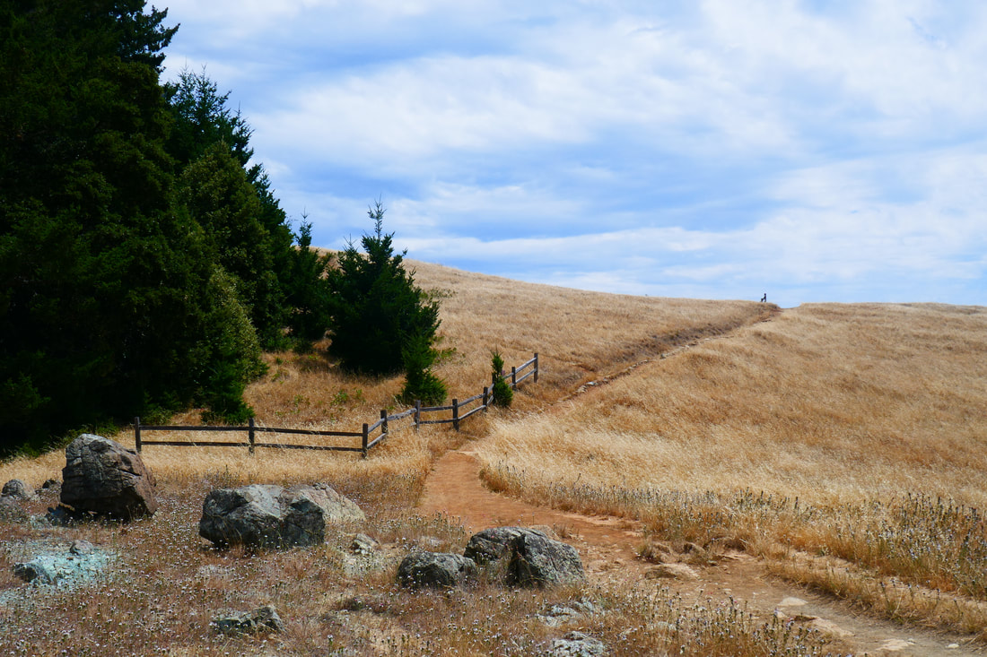
I knew that going directly up the hill would get us to a trail or service road that would get us to the theater, so we stomped our way up an ever-less visible trail, with plenty of interesting grasses and some wildflowers. (The grass provided me with my second-ever tick bite which I found later that night. Check for ticks!)
Much of the faded trail we took was in an open spaced with forest on both sides. Looking at the map, later, when in satellite view, I could see the open space between the Easy Grade Trail and the Bootjack Trail, both of which we’d intended to try that day, one going up and the other going down.
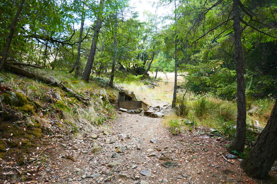
Our middle trail was quite beautiful, however, and had some very interesting tree and rock formations. At one point, we crossed a part of the Easy Grade Trail but kept on our unnamed path. The last push up the hill was a bit slippery with gravel and rocks, and we were definitely sweating and needed our water and a snack in addition to a cool-off break.
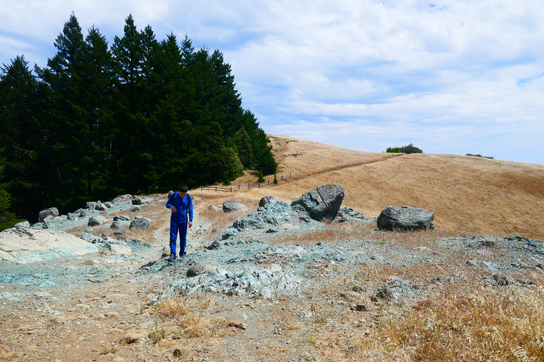
There is a wide area of greenish rock which I believe is serpentine where our path connected to the Old Mine Trail. From here there is a diagonal connection to the Old Mine Spur which leads to the Mountain Theater Trail. From that junction was a mere 0.2 miles to the theater, which has many more well-marked trail signs as it is the focal point for many visitors.
For those who are confident enough to go a little off trail, I can say that we knew by our senses that going straight up would get us to main trails leading to the theater, and if we’d strayed too far to either side we’d have hit a better known trail. Having said that, it’s always good to have maps, both paper and electronic, and to know your own limits. It was just autistic son Sean and me out for a weekday adventure on Mt. Tam. We did not meet any mountain lions or rattlesnakes, though we managed to have more of an adventure than we’d originally bargained for. We definitely enjoyed the scenery of our faded path.
The clearly marked trail option from the Mountain Theater back to the Bootjack Campground parking area is Bootjack Trail, which is marked with trail signs starting from near the theater. That is a zigzag switchback trail that means longer distance but less of an incline.
(Mountain Theater from Bootjack Campground Hike Notes were originally paired with the “The Trail Less Traveled” Insights post.)
Click Insights/Hike Update News for inspiring reflections. Browse hikes on the main Hikes page or on the Hike Search by Area page. Check out selected articles and interviews under Media. Click World Walks to see or share favorite family-friendly walks! Stay in touch with Lisa Louis and HikingAutism via Contact. See products with inspiring designs that support the efforts of HikingAutism under Support/Shop. The Links page lists a loose collection of helpful information links.
Check the Home page for the broader background story. If you’re not able to take one of these Northern California hikes, hopefully you can enjoy the photo galleries at the bottom of each hike page! Feel free to share and follow on Facebook at HikingAutism, follow on Twitter at @HikingAutism and Instagram at lisalouis777
(scroll to bottom for photo gallery)
Location: Bootjack Campground parking area, Mount Tamalpais State Park
Starting Point: Bootjack parking area, 895 Panoramic Highway, Mill Valley, CA 94941
Info links:
For all web links, if a link doesn’t jump directly, copy and paste into browser.
For online map application searches, input “Bootjack Campground Parking”
Mount Tamalpais State Park info link (CA State Parks):
https://www.parks.ca.gov/?page_id=471
Muir Woods and Vicinity Trail Map (National Park Service):
https://www.nps.gov/goga/planyourvisit/upload/map-muwo-trail-2019-small.pdf
Mount Tamalpais brochure with map (California State Parks):
https://www.parks.ca.gov/pages/471/files/MountTamalpaisSPFinalWebLayout110816.pdf
Distance:
We ended up taking an unmarked trail so don’t have official distance information. Since the Bootjack Trail, which has a lot of distance added with its many switchbacks, says 0.8 miles to the Mountain Theater, my guess is that our off-trail adventure was more like 0.4 miles for the straight up climb, with 0.3 miles more to get to the Mountain Theater once we reached the top of the hill to the Old Mine Trail and then Old Mine Spur to the Mountain Theater Trail.
Considerations:
• The parking area is fairly large, but as is the case at many trailheads, it gets more crowded on weekends.
• There are toilets at the trailhead parking area.
• Follow health, safety signs, and wildlife information signs.
• Having a poison oak scrub like Technu is handy for any trail.
• As with any Bay Area outing, bring layers. You may be hot in the sun one moment and shivering under fog and a chilly breeze the next.
The trail:
The Bootjack camp sites rise up to the right from behind the bathroom buildings. Stone stairways start hikers out, winding through various campsites, and come to some trail signs, one of which directs hikers along Bootjack Trail. There’s a somewhat faded path stretch that then connects to some wooden steps.
After the stairs, there is a service road with signs. We did not turn right and walk a few yards to see the Bootjack Trail sign. Instead, we went straight ahead on a lesser-marked trail called the Riding and Hiking Trail which would connect us to the Easy Grade Trail as another way up to the Mountain Theater.
We did not, however, take the sharp left along the more clearly worn Riding and Hiking Trail, but instead started chugging straight up the mountain. It still seemed like a marked trail, and at that point, I hadn’t realized that we’d missed the Bootjack Trail connector by a few yards.
I knew that going directly up the hill would get us to a trail or service road that would get us to the theater, so we stomped our way up an ever-less visible trail, with plenty of interesting grasses and some wildflowers. (The grass provided me with my second-ever tick bite which I found later that night. Check for ticks!)
Much of the faded trail we took was in an open spaced with forest on both sides. Looking at the map, later, when in satellite view, I could see the open space between the Easy Grade Trail and the Bootjack Trail, both of which we’d intended to try that day, one going up and the other going down.
Our middle trail was quite beautiful, however, and had some very interesting tree and rock formations. At one point, we crossed a part of the Easy Grade Trail but kept on our unnamed path. The last push up the hill was a bit slippery with gravel and rocks, and we were definitely sweating and needed our water and a snack in addition to a cool-off break.
There is a wide area of greenish rock which I believe is serpentine where our path connected to the Old Mine Trail. From here there is a diagonal connection to the Old Mine Spur which leads to the Mountain Theater Trail. From that junction was a mere 0.2 miles to the theater, which has many more well-marked trail signs as it is the focal point for many visitors.
For those who are confident enough to go a little off trail, I can say that we knew by our senses that going straight up would get us to main trails leading to the theater, and if we’d strayed too far to either side we’d have hit a better known trail. Having said that, it’s always good to have maps, both paper and electronic, and to know your own limits. It was just autistic son Sean and me out for a weekday adventure on Mt. Tam. We did not meet any mountain lions or rattlesnakes, though we managed to have more of an adventure than we’d originally bargained for. We definitely enjoyed the scenery of our faded path.
The clearly marked trail option from the Mountain Theater back to the Bootjack Campground parking area is Bootjack Trail, which is marked with trail signs starting from near the theater. That is a zigzag switchback trail that means longer distance but less of an incline.
(Mountain Theater from Bootjack Campground Hike Notes were originally paired with the “The Trail Less Traveled” Insights post.)
Click Insights/Hike Update News for inspiring reflections. Browse hikes on the main Hikes page or on the Hike Search by Area page. Check out selected articles and interviews under Media. Click World Walks to see or share favorite family-friendly walks! Stay in touch with Lisa Louis and HikingAutism via Contact. See products with inspiring designs that support the efforts of HikingAutism under Support/Shop. The Links page lists a loose collection of helpful information links.
Check the Home page for the broader background story. If you’re not able to take one of these Northern California hikes, hopefully you can enjoy the photo galleries at the bottom of each hike page! Feel free to share and follow on Facebook at HikingAutism, follow on Twitter at @HikingAutism and Instagram at lisalouis777